Mapping Your Way - Class 5 Maths - Extra Questions
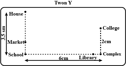
Use a ruler to measure the distance in cm between the places joined by dotted lines. If the map has been drawn using the scale 1 cm :10km, find the actual distances between
1) School and Library
2) College and Complex
3) House and School
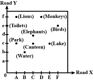
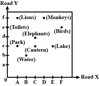
Study the given map of a zoo and answer the following questions.
Give the location of lions in the zoo.
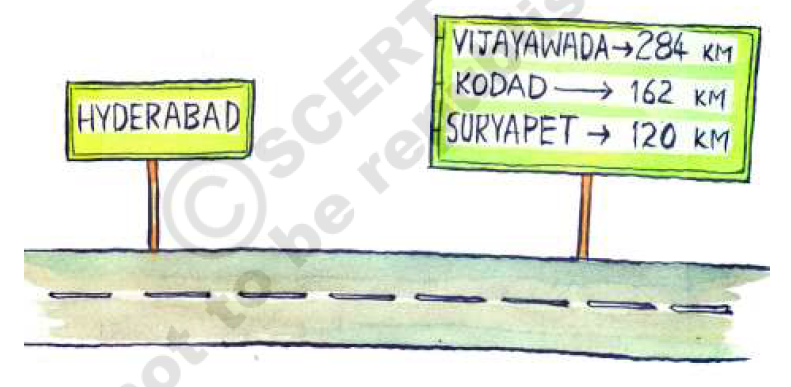
Ashish is travelling from Hyderabad to Vijayawada. He saw this board on the highway road while starting. How much distance he has to travel from Hyderabad to Vijayawada?
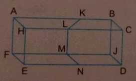
How many points are marked in the following figures? Name them.
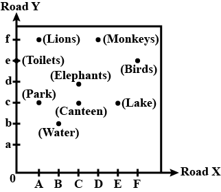
Study the given map of a zoo and answer the following questions.
Give the location of canteen.
Ashish is travelling from Hyderabad to Vijayawada. He saw this board on the highway road while starting. Which distance is more - Suryapet to Kodad or Kodad to Vijayawada?

The distance between school and house of a girl is given by 5 cm in a picture, using the scale 1cm: 5 km. Find the actual distance between the two places?
Study the given map of a zoo and answer the following questions.
Where are the toilets located?
In the map of India, the distance between two cities is $$13.8\,cm$$.
Taking scale : $$1\,cm = 12\,km$$, find the actual distance between these two cities.
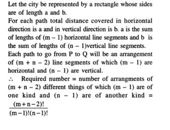
The streets of a city are arranged like the lines of a chessboard. There area $$m$$ streets running north and south and $$n$$ cast and west. Find the number of ways in which a man can travel from the N.W. to the S.E. corner going the shortest possible distance.
Find out the scale used to draw the map using the distance information given.
| Places | Actual distance | Distance on map |
| From Begalore to Lucknow | $$1855$$ km | $$5.3$$ cm |
Height of a building is $$9$$ m and this building is represented by $$9$$ cm on a map. What is the scale used for the map?
If actual distance between two places $$A$$ and $$B$$ is $$110\ km$$ and it is represented on a map by $$25\ mm$$. Then the scale used is _____.
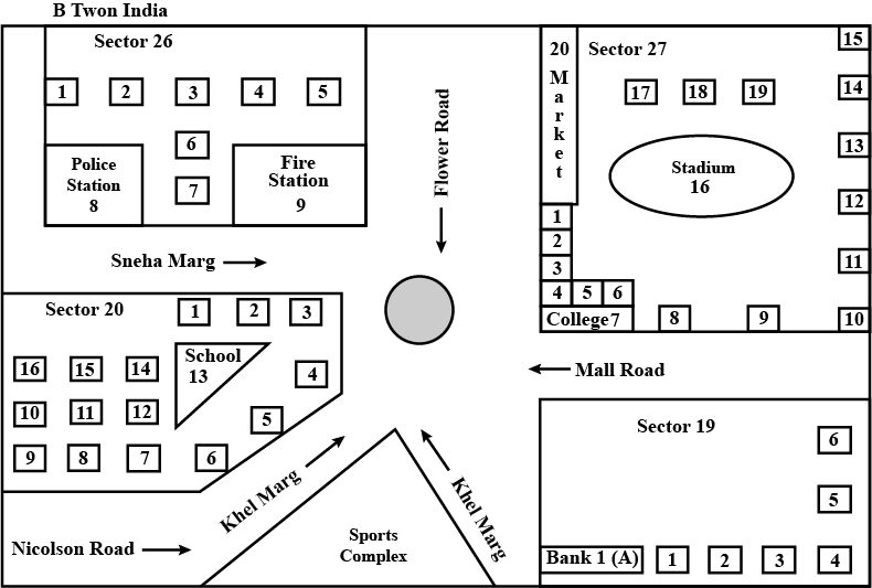
Look at the map given below.
Houses
Now answer the following questions.
a) Name the roads that meet at round about.
b) What is the address of the stadium?
c) On which road is the Police Station situated?
d) If Ritika stays adjacent to bank and you have to send her a card, what address will you write?
e) Which sector has maximum number of houses?
f) In which sector is Fire Station located?
g) In the map, how many sectors have been shown?
If $$4\ km$$ on a map is represented by $$1\ cm$$, then $$16\ km$$ is represented by _______ $$cm$$ .
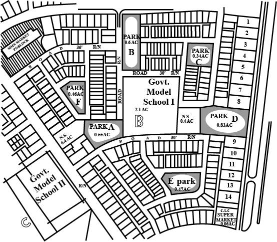
Refer to the given map to answer the following questions.
a) What is the built-up area of Govt.Model School I?
b) Name the school shown in the picture.
c) Which park is nearest to the dispensary?
d) To which block does the main market belong?
e) How many parks have been represented in the map ?
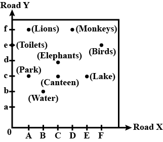
Study the given map of a zoo and answer the following question.
(D, f) and (C,d) represent locations of which animals in the zoo?
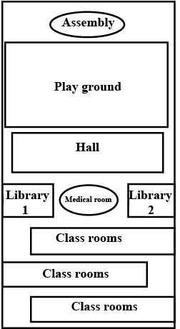
Draw a map of your school playground. Mark all necessary places like 2 libraries, Playground, Medical Room, Classroom, Assembly area, etc.
Rashmi has a road map with a scale of $$1$$km representing $$18$$ km. She drives on road for $$72$$ km. What would be her distance covered in the map?
A map to scale is drawn for a state. If it takes $$4$$ hours to travel a distance shown as $$8 cm$$ on the map, find the time required to travel from city $$A$$ to city $$B$$ which are shown away by $$5cm$$ distance from each other on the map.
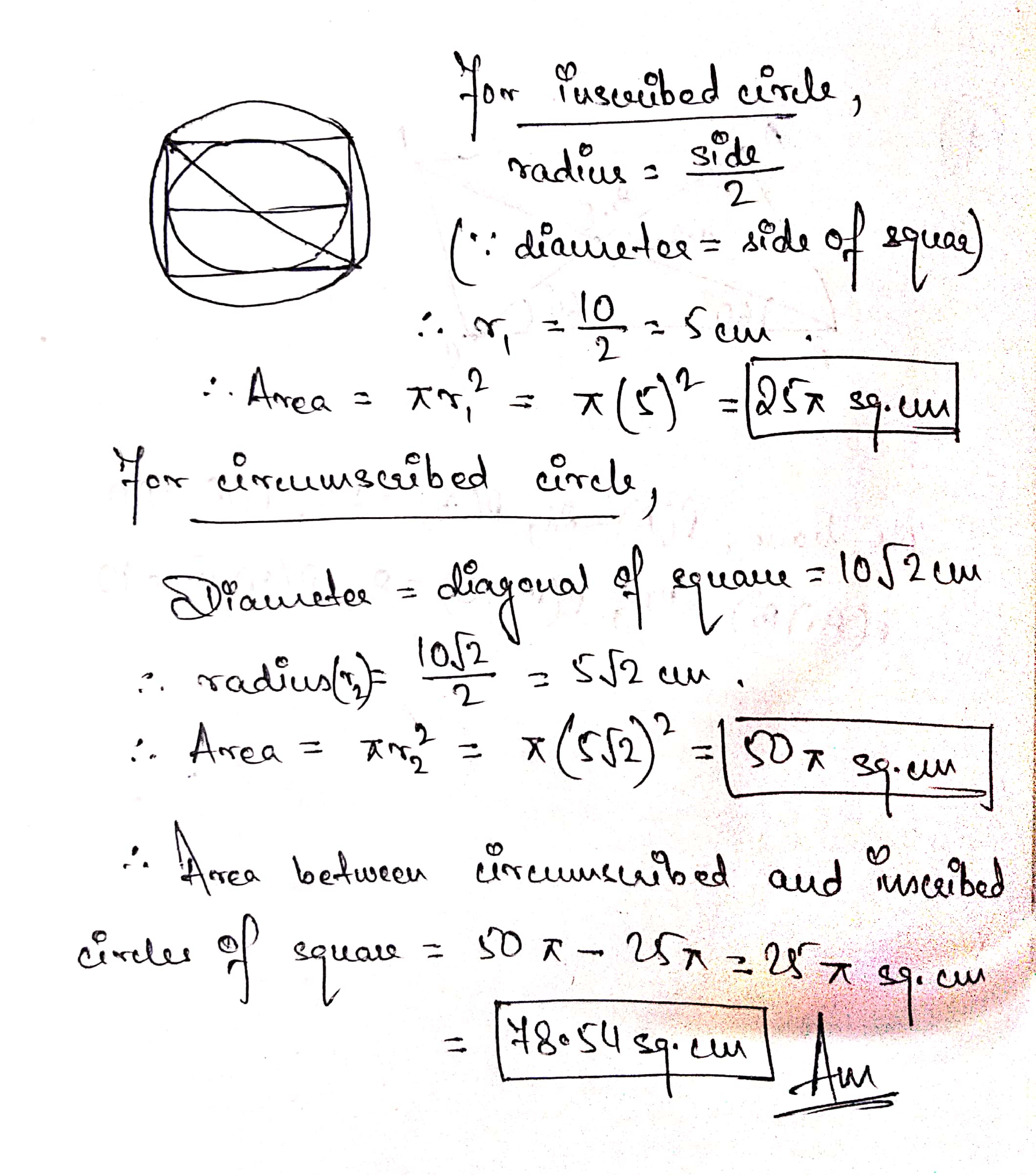
The side of a square is 10 cm. Find the area between inscribed and circumscribed circles of the square.
Class 5 Maths Extra Questions
- Area And Its Boundary Extra Questions
- Be My Multiple I Will Be Your Factor Extra Questions
- Boxes And Sketches Extra Questions
- Can You See The Pattern Extra Questions
- Does It Look The Same Extra Questions
- How Big How Heavy Extra Questions
- How Many Squares Extra Questions
- Mapping Your Way Extra Questions
- Parts And Whole Extra Questions
- Shapes And Angles Extra Questions
- Smart Charts Extra Questions
- Tenths And Hundreths Extra Questions
- The Fish Tale Extra Questions
- Ways To Multiply And Divide Extra Questions
